PointGeometry
汇总
PointGeometry 对象是在给定比例处既无长度亦无面积的形状。
讨论
在许多地理处理工作流中,您可能需要使用坐标和几何信息运行特定操作,但不一定想经历创建新(临时)要素类、使用光标填充要素类、使用要素类,然后删除临时要素类的过程。 可以使用几何对象替代输入和输出,从而使地理处理变得更简单。 使用 Geometry 、 Multipoint 、 PointGeometry 、 Polygon 或 Polyline 类可以从头开始创建几何对象。
在创建几何对象的过程中,将执行一个简化过程,以使几何根据其几何类型在拓扑上保持一致。 例如,将校正可能自相交的面,或包含错误环方向的面。 坐标可能会在几何空间参考的分辨率范围内移动。
可以使用以下运算符代替几何方法:
|
Python 运算符 |
几何方法 |
|---|---|
|
|
|
|
|
|
|
|
|
|
|
|
|
|
|
|
|
|
例如,要联合两个几何对象, g3 = g1 | g2 等效于 g3 = g1.union(g2) 。
+ 运算符将使用第一个几何的几何类型 (dimension) 来确定输出的几何类型。
语法
PointGeometry(inputs, {spatial_reference}, {has_z}, {has_m}, {has_id})
| 名称 | 说明 | 数据类型 |
|---|---|---|
|
inputs |
A |
Point |
|
spatial_reference (可选) |
The spatial reference of the new geometry. (默认值为 None) |
SpatialReference |
|
has_z (可选) |
Specifies whether the geometry will be z-enabled. (默认值为 False) |
Boolean |
|
has_m (可选) |
Specifies whether the geometry will be m-enabled. (默认值为 False) |
Boolean |
|
has_id (可选) |
Specifies whether the geometry will support point IDs. (默认值为 False) |
Boolean |
属性
| 名称 | 说明 | 数据类型 |
|---|---|---|
|
JSON (只读) |
采用字符串形式的几何的 Esri JSON 制图表达。 提示:通过 |
String |
|
WKB (只读) |
OGC 几何的熟知二进制 (WKB) 表示。 该属性以连续字节流的形式提供几何值的可移植表示。 |
Bytearray |
|
WKT (只读) |
OGC 几何的熟知文本 (WKT) 表示。 该属性以文本字符串的形式提供几何值的可移植表示。 几何中的所有真曲线都将在 WKT 字符串的近似曲线中进行增密。 |
String |
|
area (只读) |
面要素的面积。 对于其他所有要素类型,面积为零。 |
Double |
|
centroid (只读) |
如果质心位于要素之内或要素之上则为真;否则为标注点。 |
Point |
|
extent (读取和写入) |
几何范围。 |
Extent |
|
firstPoint (只读) |
几何的第一个坐标点。 |
Point |
|
hasCurves (只读) |
指定几何是否具有曲线。 |
Boolean |
|
hullRectangle (只读) |
凸包矩形坐标对的空格分隔字符串。 |
String |
|
isMultipart (只读) |
指定几何的部分数是否大于 1。 |
Boolean |
|
labelPoint (只读) |
标注位置所在的点。 该点始终位于要素之内或之上。 |
Point |
|
lastPoint (只读) |
要素最后一个坐标。 |
Point |
|
length (只读) |
线状要素的长度。 该计算将使用 2D 笛卡尔算法。 对于点和多点几何,长度为零。 对于面几何,长度将是边界的 2D 长度。 |
Double |
|
length3D (只读) |
线状要素的 3D 长度。 该计算将使用 3D 笛卡尔算法。 对于点和多点几何,长度为零。 对于面几何,长度将是边界的 3D 长度。 注意:该操作不执行水平和垂直坐标系之间的单位转换。 假设 x、y 和 z 坐标在同一线性单位中。 注意:此属性仅适用于投影数据。 |
Double |
|
partCount (只读) |
要素的几何部分数。 |
Integer |
|
pointCount (只读) |
要素的总点数。 |
Integer |
|
spatialReference (只读) |
几何的空间参考。 |
SpatialReference |
|
trueCentroid (只读) |
要素的重心。 |
Point |
|
type (只读) |
几何类型: |
String |
方法
angleAndDistanceTo(other, {method})
返回到点或面的角度和距离的元组。
| 名称 | 说明 | 数据类型 |
|---|---|---|
|
other |
The second geometry. If the geometry is a polygon, the distance is measured to the centroid of the polygon. |
PointGeometry |
|
method (可选) |
Specifies the method that will be used to measure distance.
(默认值为 GEODESIC) |
String |
返回值
| 数据类型 | 说明 |
|---|---|
|
tuple |
将一组角(以度为单位)和距离(以米为单位)返回到另一个点。 |
boundary()
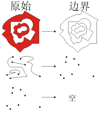
构造几何边界。
返回值
| 数据类型 | 说明 |
|---|---|
|
Object |
面的边界是折线。 折线的边界是多点,对应于线的端点。 点或多点的边界是空的点或多点。 |
buffer(distance)
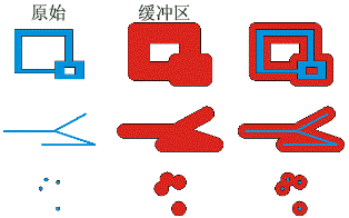
在距几何的指定距离处构造一个面。
| 名称 | 说明 | 数据类型 |
|---|---|---|
|
distance |
The buffer distance. The buffer distance is in the same units as the geometry that is being buffered. A negative distance can only be specified for a polygon geometry. |
Double |
返回值
| 数据类型 | 说明 |
|---|---|
|
Polygon |
缓冲的面几何。 |
clip(envelope)
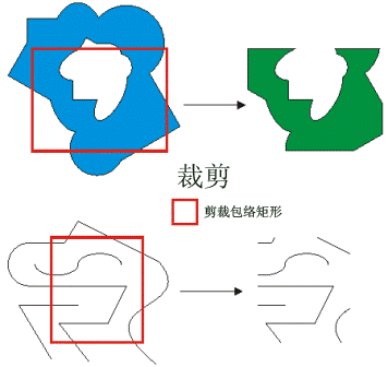
构造几何体与指定范围的交集。
| 名称 | 说明 | 数据类型 |
|---|---|---|
|
envelope |
An |
Extent |
返回值
| 数据类型 | 说明 |
|---|---|
|
Object |
将输出几何体按指定范围进行裁剪。 |
contains(second_geometry, {relation})
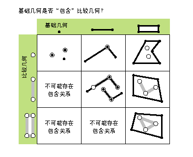
指定基础几何是否包含比较几何。
contains 方法与 within 方法相反。
本图仅显示 True 关系。
| 名称 | 说明 | 数据类型 |
|---|---|---|
|
second_geometry |
A second geometry. |
Object |
|
relation (可选) |
Specifies the spatial relationship type that will be used.
(默认值为 None) |
String |
返回值
| 数据类型 | 说明 |
|---|---|
|
Boolean |
返回此几何是否包含第二个几何。 |
convexHull()
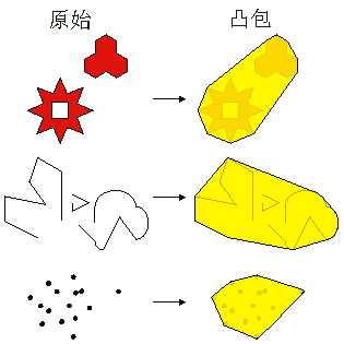
构造具有最小边界多边形的几何,以便所有外角均为凸角。
返回值
| 数据类型 | 说明 |
|---|---|
|
Object |
生成的几何。 单个点的凸包为该点本身。 |
crosses(second_geometry)
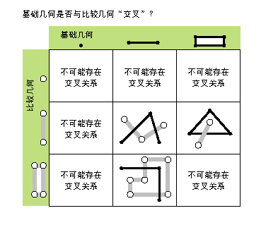
指定两个几何是否相交于较小形状类型的几何。
如果两条折线仅共用公共点(至少有一个点不是端点),则这两条折线交叉。 如果折线和面在面的内部共享一条折线(不等于整条折线)或一个公共点(对于垂直线),那么该折线与面交叉。
本图仅显示 True 关系。
| 名称 | 说明 | 数据类型 |
|---|---|---|
|
second_geometry |
A second geometry. |
Object |
返回值
| 数据类型 | 说明 |
|---|---|
|
Boolean |
返回两个几何是否相交于较小形状类型的几何。 |
difference(other)
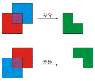
构造一个几何,该几何仅由基础几何所特有、而其他几何所没有的区域组成。
下图显示当红色多边形为源几何时的结果:
| 名称 | 说明 | 数据类型 |
|---|---|---|
|
other |
A second geometry. |
Object |
返回值
| 数据类型 | 说明 |
|---|---|
|
Object |
生成的几何。 |
disjoint(second_geometry)
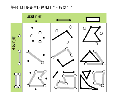
指定基础几何和比较几何是否具有公共点。
此方法返回 False 时,两个几何相交。
本图仅显示 True 关系。
| 名称 | 说明 | 数据类型 |
|---|---|---|
|
second_geometry |
A second geometry. |
Object |
返回值
| 数据类型 | 说明 |
|---|---|
|
Boolean |
返回两个几何是否具有公共点。 |
distanceTo(other)
返回两个几何之间的最小距离。距离将采用几何空间参考的单位。如果两个几何相交,则最小距离为 0。
两个几何必须具有相同的投影。
| 名称 | 说明 | 数据类型 |
|---|---|---|
|
other |
第二个几何。 |
Object |
返回值
| 数据类型 | 说明 |
|---|---|
|
Double |
两个几何之间的距离。 |
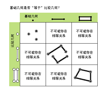
equals(second_geometry)
指定基础几何和比较几何是否具有相同的形状类型,并在平面中定义相同的点集。 这仅是 2D 的比较;已忽略 m 值和 z 值。
本图仅显示 True 关系。
| 名称 | 说明 | 数据类型 |
|---|---|---|
|
second_geometry |
A second geometry. |
Object |
返回值
| 数据类型 | 说明 |
|---|---|
|
Boolean |
返回两种几何是否具有相同的形状类型,并在平面中定义相同的点集。 |
getGeohash(precision)
将经纬度的地理坐标系坐标中的 PointGeometry 转换为精确到 geohash 格网中边界框内的任意精度的 geohash 字符串。
| 名称 | 说明 | 数据类型 |
|---|---|---|
|
precision |
The precision length of the hash string that will be returned for the (默认值为 8) |
Integer |
返回值
| 数据类型 | 说明 |
|---|---|
|
String |
将根据输入点几何经纬度坐标和精度长度返回 geohash 字符串。 |
import arcpy

# Spatial reference set to GCS_WGS_1984
spatial_reference = arcpy.SpatialReference(4326)
pnt = arcpy.Point(-88.236, 40.096)
pnt_geometry = arcpy.PointGeometry(pnt, spatial_reference)
print(pnt_geometry.getGeohash(6))  # dp1k05
getPart({index})
如果指定了索引,则将返回几何特定部分的 Point 对象的 Array 对象。 如果未指定索引,则返回的 Array 对象将包含每个几何部分的 Point 对象的 Array 。
getPart 方法等同于建立对象索引;即 obj.getPart(0) 等同于 obj[0] 。
| 名称 | 说明 | 数据类型 |
|---|---|---|
|
index (可选) |
The index position of the geometry. |
Integer |
返回值
| 数据类型 | 说明 |
|---|---|
|
Array |
生成的 |
intersect(other, dimension)
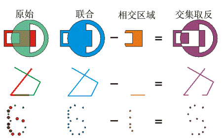
构造一个几何,它是两个输入几何的几何交集。 不同的维数可用于创建不同的 shape 类型。
对于同一 shape 类型的两个几何体,其交集为仅包含原始几何重叠区域的几何。
为了更快地获取结果,请在调用 intersect 类之前先测试两个几何体是否 disjoint 。
| 名称 | 说明 | 数据类型 |
|---|---|---|
|
other |
The second geometry. |
Object |
|
dimension |
Specifies the topological dimension (shape type) of the resulting geometry.
|
Integer |
返回值
| 数据类型 | 说明 |
|---|---|
|
Object |
作为两个输入几何体的交集的新几何体(点、多点、折线或面)。 |
move({dx}, {dy}, {dz})
沿 x、y 和 z 轴将几何移动指定的距离以创建新几何。
| 名称 | 说明 | 数据类型 |
|---|---|---|
|
dx (可选) |
The distance the geometry will be moved along the x-axis. (默认值为 0.0) |
Double |
|
dy (可选) |
The distance the geometry will be moved along the y-axis. (默认值为 0.0) |
Double |
|
dz (可选) |
The distance the geometry will be moved along the z-axis. The geometry must be z-aware and have z-values. (默认值为 0.0) |
Double |
返回值
| 数据类型 | 说明 |
|---|---|
|
Geometry |
沿 x、y 和 z 轴按指定距离移动的输出几何。 |
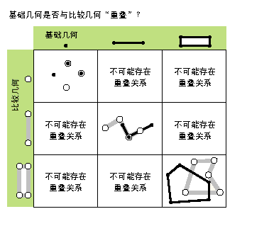
overlaps(second_geometry)
指定两个几何的交集是否具有与其中一个输入几何相同的形状类型,并且不等于任一输入几何。
本图仅显示 True 关系。
| 名称 | 说明 | 数据类型 |
|---|---|---|
|
second_geometry |
A second geometry. |
Object |
返回值
| 数据类型 | 说明 |
|---|---|
|
Boolean |
返回两个几何的交集是否具有与其中一个输入几何相同的尺寸。 |
pointFromAngleAndDistance(angle, distance, {method})
使用指定的测量类型按给定的角度(以度为单位)和距离(采用几何空间参考的单位)返回点。
| 名称 | 说明 | 数据类型 |
|---|---|---|
|
angle |
The angle in degrees to the returned point. |
Double |
|
distance |
The distance in the units of the geometry's spatial reference to the returned point. |
Double |
|
method (可选) |
Specifies the method that will be used to measure distance.
(默认值为 GEODESIC) |
String |
返回值
| 数据类型 | 说明 |
|---|---|
|
PointGeometry |
按给定的角度(以度为单位)和距离(以米为单位)返回点。 |
projectAs(spatial_reference, {transformation_name})
将几何从一个空间参考投影到另一个空间参考。
当几何对象和目标空间参考没有公共基准面时,请指定 transformation_name 参数值。 有关详细信息,请参阅 地理基准面变换 和 ListTransformations 。
当满足以下条件时,将执行垂直变换:
几何对象具有 z 坐标。
几何对象的空间参考和
spatial_reference参数值均具有垂直坐标系。transformation_name参数值为垂直变换。
当 transformation_name 参数值是垂直变换,并且几何对象和目标空间参考都没有垂直坐标系时,函数将运算失败,并显示 ValueError 异常。
如果几何对象或 spatial_reference 参数值具有 未知空间参考 ,则输出几何的空间参考将是 spatial_reference 参数值的空间参考。 不建议使用未知空间参考进行分析。
projectAs 方法不会修改 m 值(如果存在)。
| 名称 | 说明 | 数据类型 |
|---|---|---|
|
spatial_reference |
The spatial reference to which the geometry will be projected. The value can be a |
SpatialReference |
|
transformation_name (可选) |
The geotransformation name. With ArcGIS Pro, if you do not specify a transformation, none will be applied. With ArcGIS Server, if you do not specify a transformation, a fallback transformation will be applied. |
String |
返回值
| 数据类型 | 说明 |
|---|---|
|
Object |
经投影的几何。 |
rotate({origin}, {rotation_angle})
将几何围绕指定原点旋转指定角度(以弧度表示)。
旋转相对于原点应用,以便几何围绕原点旋转。 原点的选择对于旋转几何的位置影响很大。
旋转不适用于 z 方向。
以下将介绍原点及其对输出的影响的一些可能的选择:
原点位于几何外(不在几何内或接触几何)- 几何的位置将发生变化,但该几何与其他以相同方式旋转的几何的相对位置保持不变。 位置将围绕原点旋转。
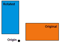
原点位于几何的质心(质心位于几何内部或接触几何)- 几何将围绕其质心旋转。
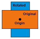
原点位于几何的顶点 - 几何将围绕所选顶点旋转。
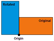
| 名称 | 说明 | 数据类型 |
|---|---|---|
|
origin (可选) |
The origin of the transformation. The argument can be either an The default origin, (默认值为 arcpy.Point(0.0, 0.0)) |
Point |
|
rotation_angle (可选) |
The angle, in radians, to rotate the geometry around its origin. The default rotation angle is 0.0 radians (no rotation). (默认值为 0.0) |
Float |
返回值
| 数据类型 | 说明 |
|---|---|
|
Geometry |
输入几何围绕指定原点旋转指定角度。 |
scale({origin}, {sx}, {sy}, {sz})
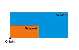
从指定的原点沿 x、y 和 z 轴按指定的因子缩放几何以创建新几何。 已变换点(或顶点)的位置由以下提供:
\(( \space (x \space - \space origin_x) \space * \space scale_x \space + \space origin_x, \space (y \space - \space origin_y) \space * \space scale_y \space + \space origin_y, \space (z \space - \space origin_z) \space * \space scale_z \space + \space origin_z \space )\)
相对于原点应用变换,以使原点保持静止,而几何围绕其扩展或收缩。 所生成几何的扩展或收缩位置和方向受到原点的显著影响。
以下将介绍原点及其对输出的影响的一些可能的选择:
原点位于几何外(不在几何内或接触几何) - 几何的大小和位置将发生变化,但几何将保持与以相同方式缩放的其他几何的相对位置。 位置将远离原点扩展或向原点收缩。
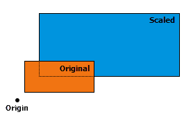
原点位于几何的质心(如果质心位于几何内部或接触几何)- 几何的大小将发生变化,但几何的位置将保持锚定在质心。 几何将围绕质心增大或收缩。
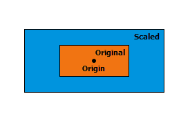
原点位于几何的顶点 - 几何的大小将发生变化,但几何的位置将保持锚定在所选顶点。 几何将从所选顶点开始增长或向顶点收缩。
| 名称 | 说明 | 数据类型 |
|---|---|---|
|
origin (可选) |
The origin of the transformation. The argument can be either an The default origin, (默认值为 arcpy.Point(0.0, 0.0, 0.0)) |
Point |
|
sx (可选) |
The factor that will be used to scale the geometry along the x-axis. (默认值为 1.0) |
Double |
|
sy (可选) |
The factor that will be used to scale the geometry along the y-axis. (默认值为 1.0) |
Double |
|
sz (可选) |
The factor that will be used to scale the geometry along the z-axis. The geometry must be z-aware and have z-values. (默认值为 1.0) |
Double |
返回值
| 数据类型 | 说明 |
|---|---|
|
Geometry |
从指定原点沿 x、y 和 z 轴按指定因子缩放的输出几何。 |
symmetricDifference(other)
构造一个几何,该几何由两个几何的并集减去其交集形成。
两个输入几何必须为同一 shape 类型。
| 名称 | 说明 | 数据类型 |
|---|---|---|
|
other |
A second geometry. |
Object |
返回值
| 数据类型 | 说明 |
|---|---|
|
Object |
生成的几何。 |
toCoordString(notation)
将 PointGeometry 转换为所选的坐标系记法。
| 名称 | 说明 | 数据类型 |
|---|---|---|
|
notation |
The coordinate system notation to be generated.
|
None |
返回值
| 数据类型 | 说明 |
|---|---|
|
String |
指定坐标系记法中的点。 |
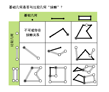
touches(second_geometry)
指定几何的边界是否相交。
当两个几何的交集不为空,但它们内部的交集为空时,说明两个几何接触。 例如,仅当点与折线的一个终点重合时,才表示点与折线接触。
本图仅显示 True 关系。
| 名称 | 说明 | 数据类型 |
|---|---|---|
|
second_geometry |
A second geometry. |
Object |
返回值
| 数据类型 | 说明 |
|---|---|
|
Boolean |
返回几何的边界是否相交。 |
union(other)
构造一个几何,该几何是输入几何的并集。
两个几何必须具有同一形状类型。
结果是单个几何,它是两个输入几何的组合。 任一输入几何中的任何内容都将成为结果的一部分。 但是,两个几何共有的内容在结果中只出现一次。
输入几何的顺序对输出没有影响。
| 名称 | 说明 | 数据类型 |
|---|---|---|
|
other |
The second geometry. |
Object |
返回值
| 数据类型 | 说明 |
|---|---|
|
Object |
生成的几何。 |
within(second_geometry, {relation})
指定基础几何是否位于比较几何之内。
within 方法是与 contains 方法相反的运算符。
本图仅显示 True 关系。
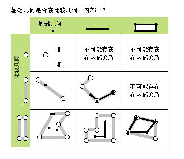
如果基础几何是这些几何的交集且其内部交集不为空,则基础几何位于比较几何之内。 within 方法是 Clementini 运算符,在空的基础几何中除外。
| 名称 | 说明 | 数据类型 |
|---|---|---|
|
second_geometry |
A second geometry. |
Object |
|
relation (可选) |
Specifies the spatial relationship type that will be used.
(默认值为 None) |
String |
返回值
| 数据类型 | 说明 |
|---|---|
|
Boolean |
返回基础几何是否位于比较几何之内。 |
代码示例
从头开始创建点要素类。
import arcpy

# Create a spatial reference from a wkid
spatial_ref = arcpy.SpatialReference(32145)

# A list of coordinate pairs
feature_info = [[1, 2], [3, 5], [7, 3]]

# A list to hold the PointGeometry objects
features = []

# For each coordinate pair, create a PointGeometry object
for pt in feature_info:
    point = arcpy.Point(*pt)

    point_geometry = arcpy.PointGeometry(point, spatial_ref)
    features.append(point_geometry)

# Persist a copy of the PointGeometry objects using CopyFeatures
arcpy.management.CopyFeatures(features, "c:/geometry/f.gdb/points")