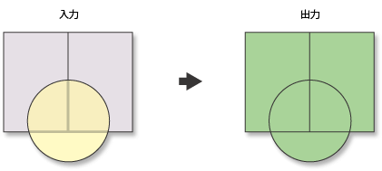
Features—A list of the input feature classes or layers. All of the input features must be polygons.
Ranks—When the distance between features is less than the cluster tolerance, the features with the lower rank will snap to the feature with the higher rank. The highest rank is one.
Features—A list of the input feature classes or layers. All of the input features must be polygons.
Ranks—When the distance between features is less than the cluster tolerance, the features with the lower rank will snap to the feature with the higher rank. The highest rank is one.
# Purpose: Union 3 feature classes

# Import the system modules
import arcpy

# Set the current workspace (to avoid having to specify the full path to the
# feature classes each time)
arcpy.env.workspace = "c:/data/data.gdb"

# Union 3 feature classes but only carry the FID attributes to the output
inFeatures = ["well_buff50", "stream_buff200", "waterbody_buff500"]
outFeatures = "water_buffers"
arcpy.analysis.Union(inFeatures, outFeatures, "ONLY_FID")

# Union 3 other feature classes, but specify some ranks for each
# since parcels has better spatial accuracy
inFeatures = [["counties", 2], ["parcels", 1], ["state", 2]]
outFeatures = "state_landinfo"
arcpy.analysis.Union(inFeatures, outFeatures)
This tool honors the Parallel Processing Factor environment. If the environment is not set (the default) or is set to 0, parallel processing will be disabled; parallel processing will not be used and processing will be done sequentially. Setting the environment to 100 will enable parallel processing; parallel processing will be used and processing will be done in parallel. Up to 10 cores will be used when parallel processing is enabled.
Parallel processing is currently supported for polygon-on-polygon, line-on-polygon, and point-on-polygon overlay operations.