Embeddings in ArcGIS Pro
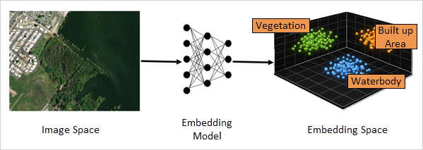
Embeddings are numerical vector representations of data that capture meaningful patterns, characteristics, and relationships in a compact mathematical form. Instead of describing data using raw pixels, spatial features, raw text, or geometry alone, embeddings transform complex inputs into high-dimensional vectors where similarity can be measured mathematically.
In embedding space, the following characteristics apply:
Similar features are positioned closer together.
Dissimilar features are positioned farther apart.
Relationships between patterns become quantifiable.
This transformation enables similarity search, clustering, change detection, and large-scale spatial analysis. Because analysis operates on precomputed vectors rather than raw data, it involves lightweight computations such as cosine similarity calculations. As a result, embedding-based workflows can run efficiently on standard CPU infrastructure, reducing reliance on GPUs and lowering computational costs.
Embeddings
To access embeddings functionality, do one of the following:
On the Analysis ribbon tab, in the Workflows section, click the Embeddings button
 . This provides access to the Generate Embeddings Using AI Models tool, the Find Similar pane, and the Merge Embeddings tool.
Use geoprocessing tools in the GeoAI toolbox's Embeddings Based Analysis toolset.
From data space to embedding space
In the original data space, the following characteristics apply:
Images are composed of pixels.
Locations are defined by geometry and spatial context.
Text is composed of words where meaning is defined by language and context.
Features may differ in shape, texture, arrangement, or surroundings.
After transformation through an embedding model, the following changes occur:
Each feature is represented as a fixed-length numeric vector.
Similar features naturally cluster together in embedding space.
Semantic similarity between features becomes measurable using vector distance metrics.
Similarly, embeddings can be generated for locations or text, where spatial or semantic similarities are captured as nearby vectors in the embedding space.
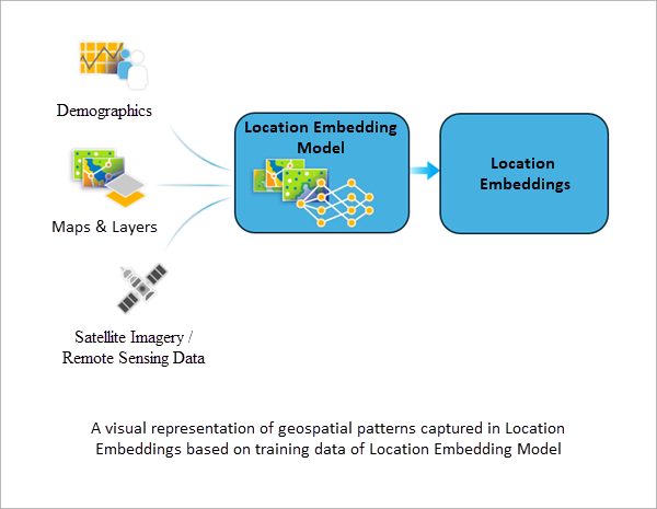
Location embeddings
A location embedding is a numerical representation of a geographic area. Instead of describing a location using one or more attributes (for example, population density, per capita income, or land cover type), an embedding represents that place using a vector of numbers.
Each location, such as a point location, county polygon, zip code, or hexbin is mapped to a multi-dimensional vector. Rather than assigning numbers to predefined variables associated with locations, a location embedding distributes information across all dimensions of the embedding. The type of information distributed across this vector depends on the model used to generate the embedding and what it was trained to learn.
Embedding data requirements
Embeddings are stored as a feature class.
To be recognized as an embeddings dataset, the feature class must contain a field named Embedding of type Blob. This field stores the numeric vector representation generated by the AI model.
Embeddings are supported to reside in the following geodatabase formats:
File geodatabases
Enterprise geodatabases (registered feature classes)
Mobile geodatabases
Embeddings are not supported to be stored as shapefiles or GeoPackage files.
Embeddings in spatial analysis
Embeddings enable the following:
Scalable similarity search across geospatial datasets.
Pattern-based retrieval without manual rule definition.
Discovery of spatial patterns not explicitly defined in attributes.
Aggregation and comparison of features across different administrative levels.
Efficient storage of rich spatial information in compact vector form.
By converting complex spatial or visual information into structured numerical representations, embeddings provide a powerful foundation for advanced geospatial AI workflows.